
Comps, cap rates and location price the market. They do not price the ground — the water it can reach, the coast beside it, the hazard it carries, the people and roads and economy moving around it. Arcanium scores what conventional valuation leaves out.
Want to see one first? The gap, measured in one county ↓
Every land valuation you have ever seen rests on the same foundation: what comparable parcels sold for, what income the site produces, where it sits relative to demand. That model was built for a stable landscape. It assumes the ground stays put, the water stays where it is, and tomorrow’s constraints look like today’s.
None of those assumptions hold any more.
Coastlines are moving. Fresh water is not where the parcel map assumes it is. Physical hazard is measured tract by tract and changes with every release. All of it is mapped, measurable, and almost entirely absent from the number on the appraisal. The market price of a parcel reflects what buyers believe today. Its real value reflects what the ground will be able to do for the next thirty years.
Those two numbers are diverging. Most portfolios are only tracking one of them.
Recent transactions, income, proximity, zoning, demand. A rear-view mirror of the market.
Sea-level exposure. How much fresh water the ground can actually reach. Physical hazard on a world scale. Which way the population and the surrounding economy are moving. The forces that decide which parcels appreciate and which quietly lose their footing.
Holdings scored on outdated inputs. Acquisitions priced against yesterday’s risk. Value that shows up in the ground years before it shows up in the comps — for whoever is looking.
 Index™
Arcanium is a geospatial intelligence platform built on a single premise: land should be valued on the physical and resource variables that determine what it is worth — not only on what the market last paid for it.
The Arcanium Index™ scores land on ten variables, one square kilometre at a time, anywhere on Earth: water, minerals, road access, agricultural potential, coastal position, population, governance, climate hazard, economic momentum and development. Every score sits on one absolute scale, so a 44 in Iowa and a 44 in Costa Rica mean the same thing and a portfolio can be compared across markets rather than only within one. Coastal ground adds sea-level scenario projections, decade by decade.
The result is a signal the comps cannot produce: where land is scored above what the market is paying for it, where it is scored below what its exposure deserves, and where the gap is widening.
Not a real estate report. A land intelligence layer.
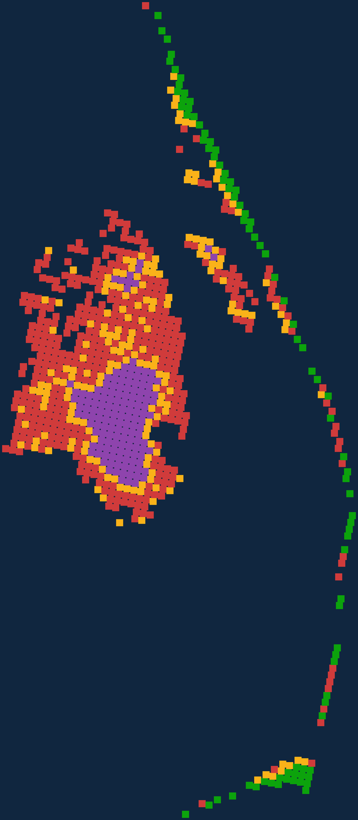
On the high sea-level scenario at 2055, 436 of its 857 land tiles submerge — but only 16% of the county’s best-scoring ground goes with them. The comps do not know which half is which. The Index does, tile by tile, today.
That is the whole argument in one county: the event is indiscriminate, the consequences are not, and the difference is already in the ground for whoever measures it.
This is the live product, not a mock-up. Step five scenarios and three decades yourself, with the Arcanium Index™ over the same ground on the same page. Open the Dare County analysis → No account needed.
Arcanium is for investors, family offices and funds with capital in — or headed toward — assets whose value is dominated by the land itself. And for the advisors, brokers, agents and attorneys who are expected to know what that land is really worth.
If your portfolio has meaningful land exposure and your valuation model has never asked how much water a parcel can reach or which decade the sea arrives, you have holdings that are being scored incompletely. That is the gap Arcanium closes.
The Index measures ground at one kilometre. It is not a parcel-level opinion, a valuation, or investment advice.